- 04h00: 64°04.8 South / 061°11.5 West (Graham Passage 7am-8am)
- 12h00: 64°32.4 South / 061°59.5 West
- 16h00: 64°37.1 South / 062°15.3 West
- 18h54: Cuverville: 64°40.9 South / 062°38.17 West
- 24h00: 64°40.8 South / 062°38.0 West
 Above, a grey bank of clouds provided the perfect backdrop over the hills, adding that contrast to the snow and water which I have come to recognise over the last few days. The passage is part of the larger Gerlach Strait (a Belgian explorer, quite a famous one too – certainly his strait looks long on the chart!).
Around 10h00 we entered the harbour around Enterprise Island. This was used by whalers at the start of the twentieth century as a perfect place to undertake their trade, protected as they are from the wilds of the southern oceans by the surrounding mountains.
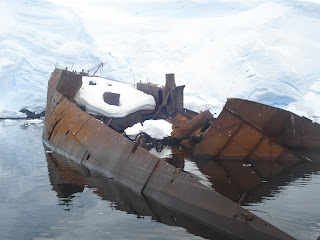
At one end of the harbour lies the wreck of the Gouvernoren, a Norwegian factory whaling ship. The ship also gives its name to the harbour. Ships such as these were moored close to the shoreline and were equipped with boiler equipment to process the whales which were brought ashore from the whaling ships. This particular ship met a grisly end, fire sweeping through the boat in 1915 and leaving it as a wreck, silhouetted against the pristine white glaciers and, in parts, exposed grey cliff.
We took the zodiacs to have a closer look. It is remarkably well preserved. It was originally called Europe – not a sign of things to come we all hoped – and its namesake slowly inched in until she was lying flush with the stricken vessel.
For once, being on a zodiac felt like the safest place to be! The practice of keeping factory whale ships close to the shore was eventually superseded by the larger whaling ships which could hunt and process the oil on board and at sea.
We got some great photos of the wreck and the Europa next to her erstwhile namesake, before taking in other parts of the harbour. We came upon a couple of crab eater seals.
Dan explained that the name is somewhat misleading. Originally named by the Norwegians the word “crabben” refers to the krill which provide the basis of the food chain here. In a similar way to whales, crab eating seals filter sea water for the krill – their teeth specially designed to allow them to do this. So no crab eating going on!
Another ice anecdote too. Often little pieces of ice on the water take on the appearance of elegant swans. So much so that early explorers gave them names: in the case of the Antarctica, the Bellinghausen Swan (he was a Russian explorer) and in the case of the Arctic, the Barents Swan (after the famous Dutch explorer). Now apparently much fun can be had at the expense of avid birdwatcher ... “have you seen the Bellinghausen Swan on your trip, Sir”, “Say again? Which page??”
Our afternoon was spent slowly meandering through the channels and islands towards our final stop of the day – Cuverville. Sometimes one needs a break on board, and I took some time down in my cabin, ostensibly to finish Shackleton’s autobiography, but also, it turned out, to catch up on some well-deserved shut eye.

We had to take care on the island not to step on the so-called penguin superhighways – these are the well-trodden paths penguins use to travel from the colonies to the sea for fishing.
A deep human footprint in the superhighways can cause the penguins all kinds of problems if they fall in them. And then we were ready to climb the hill. Cristina, one of our guides, reckoned it was 300 meters. I’m pretty sure that was an underestimate.
It certainly felt more, hiking through snow which could easily reach one’s knees at times and carrying the extra weight of many clothes layers and heavy boots. Cue memo to myself to get back on the fitness regime back home!
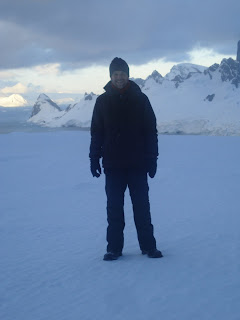
Anyway, the walk up the hill was well worth it as the views were simply stunning. We had a glorious panorama from the top, looking out at the channels surrounding this small island, and upwards towards the peaks framing them on the other side.
Naturally, we all reverted to our youth and enjoyed many snow ball fights on the way up and way down! Of course, the way down was also great fun as we were able to sledge down some of the steeper slopes, and I found running through the thick snow surprisingly easy on the steeper sections. Very enjoyable and no broken bits to report!
Oh, and I nearly forgot. Half way up the slope we stopped to enjoy the sight of another penguin colony and were treated, if that’s the right word, to two penguins getting down to mating business! I didn’t actually see them, but certainly heard a kind of call I hadn’t come across before! Great evening, and for the penguins too...


No comments:
Post a Comment