Sunday, December 27, 2009

Booth and Peterman Islands

Wednesday 9 December, Booth and Peterman Islands

Once again Europa departed as the most part of its crew were out for count below. Emerging some hours later it was something of a surprise to see the changed weather conditions, although the Captain had warned of the approaching low pressure system yesterday evening. Instead of bright blue skies and piercing sunshine, clouds shrouded the peaks and soon a blizzard was blowing across the Europa as it ploughed on, this time, and for the first time, heading northwards and back towards Ushuaia. But before then, many things still to see. The initial programme today was due to see us take in a tour of the Yaluah islands, not landing, but Europa cruising to take in the Adelie penguins.

The Adelie are another form of penguins, one which are generally found further southwards. We have just about reached their outer limit.

The Adelie are distinguished from the Chinstrap by their facial markings – explanatory photos should reveal all:

However this part of the programme was abandoned due to the inclement weather – no one, not even the hardiest of souls, fancied penguin spotting from a wind and snow swept bow of the Europa! We’re on holiday after all, aren’t we?! But the crew came up with a good alternative.

We landed at Booth Island, further north and, I think, on the same level as the northern entrance to the Lemaire Channel. We suddenly realised how fortunate we have been with the weather. A blowing gale, horizontal snow in our faces made for a completely different experience from our last few days.

But a good change it was too. We could say we had experienced a “realer” Antarctica! We hiked part way across the island to find an old stone structure which was used to house meteorological instruments in the first part of this century.

Leaving Booth Island, we backtracked on ourselves slightly to take in Peterman Island. Here we were due to see our first large grouping of adelie penguins, and we were not to be disappointed.

But first things first, climbing off the beach we nearly stumbled on a weddel seal, laying out across the beach. It was extraordinary to see this animal so up close, and so at peace. I thought he was sleeping, but it turned out he wasn’t, merely “resting” and probably keeping half an eye open to check on us funny aliens!

We walked around the island, checking out the various rockeries of adelie, chinstrap and gentoo penguins. I managed to see one pair of gentoos swapping positions on their eggs.

It was interesting to watch the ritual they have as they change places. Quite a lot of fussing goes on, and naturally several bouts of the throaty call we have come to recognise over the last few days!

Back on the boat we enjoyed a relaxing evening back on ship, for the first time in several days there were no hiking trips planned! Sometimes it is good to be able to relax and catch up on blogging and photo selection, even more so at the moment as we have a photo competition on board! Surely my pic of a penguin crapping must be a candidate for best picture in the wildlife category?!

Lemaire to Vernadsky

Tuesday 8 December, Lemaire Channel to Vernadsky Base
  • 04h00: 64°53.6 South / 062°54.3 West
  • 08h00: 64°58.4 South / 063°21.6 West
  • 12h00: 65°06.8 South / 064°00.7 West
  • Vernadsky Base: 65°14.8 South / 064°16.61 West
Europa departed while most of its crew were fast asleep, leaving behind Paradise Harbour and setting course for the Lemaire Channel and our most southerly destination – the Ukrainian research base, Vernadsky.

The Lemaire Channel is a breathtaking scene, an 11km long channel, surrounded by mountains and glaciers with at times a mere width of a 1km. Continuing our theme of Belgian influence, the Channel was named after a Belgian explorer in the Congo, again by that chap Gerlach.

The Channel lays along a southwest / northeast axis, linking Flandres Bay and Bismarck Strait to the north with French Passage to the southwest, with the Penola Strait sandwiched in between. Maintaining a British presence, the mountains to the east are suitably named after Shackleton, while the island to the west also sounds vaguely Anglo-Saxon = Booth! The passage through the Lemaire Channel was a sight to behold, the weather stunning with a clear view far down the channel and up to the peaks of the mountains. The Captain said it was only the second time in 10 visits that he had been able to see the peaks. We once again understood how lucky we had been with the weather!

And then we caught sight of our two humpback whales. Off to starboard they were elegantly making their meandering way up the Channel past us towards the northern side.

The Europa altered course and soon we were in hot pursuit, a clutch of whale papparizzi looking for the perfect shot. Mine, far from being perfect, caught some of the scene, while the whales seemingly played hide and seek with the boat. But better than taking the photos was to stand still and simply take in the atmosphere of being in the presence of such magnificent animals.

Continuing along the Channel, our path slowly broadened out as we entered the Penola Strait.

This stretch of watch was at times still as a lake, the numerous icebergs reflected beautifully in the deep blue waters.

From here the horizon opened up southwards, towards our final destination of Vernadsky, while aft we could see the mountains slowly close in around the entrance to the Lemaire Channel.

And then Vernadsky. Formerly known as Faraday, or Base F, under British control from the early 1940s until the early 1990s when the Brits sold it for a pound to the Ukrainians.

There was some debate as to the extent of scientific research being carried out in the station. Some speculated that the base was more of a flag carrying exercise than any serious scientific endeavour.

In Dan’s view – and the most authoritative we have – the base ranks well alongside comparable monitoring bases: no groundbreaking research, but solid data collection and monitoring. But certainly they are known for one thing: their bar and homemade vodka! Following a brief tour of the base, we all quickly headed upstairs for a drink – and in some cases (no, not mine) a few!

The bar was quite surreal, a mix of its British roots and recent Ukrainian infusion. “Local” Ukrainian music certainly added more flavour and parts of our crew danced with the locals while others downed the rather pleasant vodka.

Back on board it was an occasion to catch up with postcard writing, enjoy the lovely sunny weather on deck – it practically felt like spring! Later after dinner a group of hardy souls headed out on another landing, this time to the original British base. Or I should say hut. It was pretty basic stuff, people lived there for up to 3 years at a stretch. I found it surprising that the Brits were setting the place up in 1943. References were made to reconnaissance work, certainly there must have been a military angle to it all at that stage? Questions, questions... On a lighter note, I maintained – with Nic’s assistance – my record of inscribing Teo and Lilly in all destinations to date – this time with massive boulders in the snow! It was backbreaking stuff I can tell you!!


Neko & Paradise Harbours

Monday 7 December, Neko & Paradise Harbours
  • 04h00: 64°40.9 South / 062°38.0 West
  • 08h00: 64°49.2 South / 062°37.5 West
  • 12h00: 64°50.6 South / 062°32.0 West
  • 16h00: 64°53.6 South / 062°52.0 West
  • 24h00: 64°54.5 South / 062°52.8 West

Today we arrived at Neko Harbour – our first continental Antarctic landfall! The harbour is named after a whaling ship which used this area as its base. We landed on one shore of the Harbour close to another large penguin colony, mostly chinstrap this time.

On the other side of the harbour glaciers swept down the mountains to reach the lake like sea. From time to time, we heard cracking sounds and noticed small parts of ice and snow coming off the glaciers, but no large pieces were to calve off. In any event, we had received the all important instruction to get clear from the beach area as quickly as possible if any were to fall. More hiking was on the agenda as most of the group set out for a nearby hilltop.

After enjoying the magnificent views at the top and the obligatory snowball fight, we sledged down to the bottom. Many of us, myself included, had brought plastic bags to aid the process. I lost mine however with seconds of starting down the slope: going headfirst it was probably best I had lost this extra speed aid as the slope was very steep – and a bit hair-raising! Fortunately I came through unscathed, but some others suffered scratches and bruises. I decided, given my injury record, not to risk another run! And the plastic bag was recovered...!

Over lunch we moved around to another area, the Argentine base of Admiral Brown.

This brought more of the same, extended long snowball fights, hiking to the top of the local summit and many attempts at sledging down.

Some of the permanent crew seemingly risked life and limb going down the steep slope backwards.

It took the group I was with us some considerable time to make the summit as I had to rescue Joan from a hole in the snow! Having managed to get stuck practically all the way up her leg I spent several minutes digging and kicking her out! Surely she didn’t really need the leg?!

In the evening we moved around to the appropriately named Paradise Harbour. A wonderfully calm bay, surrounded by the most majestic mountains and sweeping glaciers.

We spent an hour or so on the zodiacs cruising around and taking it all in. It was a lovely sight, watching as the sun slowly set behind the mountains – and this was at around 22h00!

Finishing off another good day, we retired to the bar for a glass of wine.


Enterprise & Cuverville Islands

Sunday 6 December, Enterprise Island, Gouvernoren Harbour, Cuverville Island
  • 04h00: 64°04.8 South / 061°11.5 West (Graham Passage 7am-8am)
  • 12h00: 64°32.4 South / 061°59.5 West
  • 16h00: 64°37.1 South / 062°15.3 West
  • 18h54: Cuverville: 64°40.9 South / 062°38.17 West
  • 24h00: 64°40.8 South / 062°38.0 West
After a calm run across during the evening we arrived this morning at the Graham Passage, an impressive narrow passage taking us towards Enterprise Island and Gouvernoren Harbour. As ever, I managed to get up just that bit too late to see the entrance into the Passage – it is reputed to be hard to identify until a ship is up close! Reassuringly we had found it by the time I scrambled out of my bunk and hit the deck. The cliffs and glaciers framed our passage, while we navigated around icebergs becalmed on the still Sunday morning water.

Above, a grey bank of clouds provided the perfect backdrop over the hills, adding that contrast to the snow and water which I have come to recognise over the last few days. The passage is part of the larger Gerlach Strait (a Belgian explorer, quite a famous one too – certainly his strait looks long on the chart!).

Around 10h00 we entered the harbour around Enterprise Island. This was used by whalers at the start of the twentieth century as a perfect place to undertake their trade, protected as they are from the wilds of the southern oceans by the surrounding mountains.

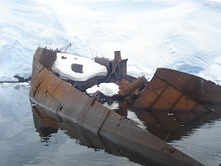
At one end of the harbour lies the wreck of the Gouvernoren, a Norwegian factory whaling ship. The ship also gives its name to the harbour. Ships such as these were moored close to the shoreline and were equipped with boiler equipment to process the whales which were brought ashore from the whaling ships. This particular ship met a grisly end, fire sweeping through the boat in 1915 and leaving it as a wreck, silhouetted against the pristine white glaciers and, in parts, exposed grey cliff.

We took the zodiacs to have a closer look. It is remarkably well preserved. It was originally called Europe – not a sign of things to come we all hoped – and its namesake slowly inched in until she was lying flush with the stricken vessel.

For once, being on a zodiac felt like the safest place to be! The practice of keeping factory whale ships close to the shore was eventually superseded by the larger whaling ships which could hunt and process the oil on board and at sea.

We got some great photos of the wreck and the Europa next to her erstwhile namesake, before taking in other parts of the harbour. We came upon a couple of crab eater seals.

Dan explained that the name is somewhat misleading. Originally named by the Norwegians the word “crabben” refers to the krill which provide the basis of the food chain here. In a similar way to whales, crab eating seals filter sea water for the krill – their teeth specially designed to allow them to do this. So no crab eating going on!

Another ice anecdote too. Often little pieces of ice on the water take on the appearance of elegant swans. So much so that early explorers gave them names: in the case of the Antarctica, the Bellinghausen Swan (he was a Russian explorer) and in the case of the Arctic, the Barents Swan (after the famous Dutch explorer). Now apparently much fun can be had at the expense of avid birdwatcher ... “have you seen the Bellinghausen Swan on your trip, Sir”, “Say again? Which page??”

Our afternoon was spent slowly meandering through the channels and islands towards our final stop of the day – Cuverville. Sometimes one needs a break on board, and I took some time down in my cabin, ostensibly to finish Shackleton’s autobiography, but also, it turned out, to catch up on some well-deserved shut eye.

Around dinner time we arrived at the Cuverville, the site of one of the largest gentoo penguin colonies in Antarctica. Apparently there are around 5000 mating pairs. You can imagine the sweet scent which accompanies such a large congregation of penguins. Certainly an aroma which came our way as we motored across the bay in the zodiacs after another dinner (this time lamb, lekke moi – as the Dutchies say!).

We had to take care on the island not to step on the so-called penguin superhighways – these are the well-trodden paths penguins use to travel from the colonies to the sea for fishing.

A deep human footprint in the superhighways can cause the penguins all kinds of problems if they fall in them. And then we were ready to climb the hill. Cristina, one of our guides, reckoned it was 300 meters. I’m pretty sure that was an underestimate.

It certainly felt more, hiking through snow which could easily reach one’s knees at times and carrying the extra weight of many clothes layers and heavy boots. Cue memo to myself to get back on the fitness regime back home!

Anyway, the walk up the hill was well worth it as the views were simply stunning. We had a glorious panorama from the top, looking out at the channels surrounding this small island, and upwards towards the peaks framing them on the other side.

Naturally, we all reverted to our youth and enjoyed many snow ball fights on the way up and way down! Of course, the way down was also great fun as we were able to sledge down some of the steeper slopes, and I found running through the thick snow surprisingly easy on the steeper sections. Very enjoyable and no broken bits to report!

Oh, and I nearly forgot. Half way up the slope we stopped to enjoy the sight of another penguin colony and were treated, if that’s the right word, to two penguins getting down to mating business! I didn’t actually see them, but certainly heard a kind of call I hadn’t come across before! Great evening, and for the penguins too...

Trinity Island

Saturday 5 December, Trinity Island
  • 04h00: 63°15.8 South / 060°40.1 West
  • 08h00: 63°36.3 South / 060°58.1 West
  • Anchor: 12h00: 63°51.4 South / 060°54.1 West
A break in our run of island landings as today was spent entirely at sea, either on board Europa on in the zodiacs iceberg spotting! But first things first. After escaping the ice at Deception we set a south westerly course in the direction of Trinity Island, crossing the Bransfield Straits. This was one of the last rougher crossings before our return trip across the Drake Passage. Fortunately, the crossing was overnight so anyone prone to seasickness could hopefully wile away the hours sleeping in their bunk – as long as they weren’t tipped out of it!

We spent a pleasant morning cruising towards Trinity Island, enjoying the landscape as it slowly slipped by and marvelling at icebergs of all types and sizes. In preparation for our iceberg spotting, Dan gave us a presentation on how glaciers are formed, the different type of icebergs as well as the formation of sea ice. I was interested in his views on the impact of climate change on this region.

In his view, and in contrast to the Arctic, it is impossible to draw conclusions on any impact climate change may be having on the Antarctic ice cap and the annual growth and subsequent retreat of the ice sheets. We watched a series of slides showing the retreat and growth of the ice sheet from February this year through to mid November. By mid and late winter the ice has extended far out in the ocean on two sides of the continent, and just past where we are visiting now on the far tip of the Peninsula. In the depths of winter the extension of ice doubles the size of the continent. Incredible.

Following another hearty lunch on deck – although no hotdogs this time – we prepared ourselves for our iceberg spotting. We took the zodiacs out for a 90 minute cruise around “iceberg alley” (the crew called it iceberg graveyard but I preferred alley...), a small channel between Trinity and Spit Islands. The prevailing winds blow icebergs into this small channel from where there is no escape and they remained trapped, caught in the shallows, held firm like ghostly shipwrecks silhouetted against the dark and imposing cliffs.

Exploring the channel everywhere we looked seemed to offer up a new vista, a new ice shape, a different colour tone of the ice, some amazing dark blues buried deep in cracks in iceberg. And there was also some wildlife in this desolate landscape. Seals had pulled themselves up on some of the marooned bergs. Including some leopard seals, the first time we had seen these awesome and feared creatures up close.

With an angular neck and rows of sharp, incisor teeth glinting in the watery sun, they certainly lived up to the impression I had formed of them. Watch out little penguins!

Back on board, it was time to celebrate Sinterklaas day – Dutch Christmas, celebrated in the evening of December 5. As part of our celebrations, we all did secret santa gifts for our crew mates. I drew Karen out of the hat and went on the practical side with my gift, including a pair of my hand heat patches since she had earlier told me how cold she had been feeling. Time will tell if this will encourage her to participate in more landings. In return, I got a “Dutch for Dummies” guide. My Dutch, already at a high level of competence, has been refined on this trip. New words such as “lekke” have been added to my burgeoning repertoire. In fact, Dutch seems to revolve around this all-purpose word, generally taken to mean “nice/good”. Lekke moi indeed.

Continuing our festive theme, we were also visted by Sinterklaas and Black Peter, arriving on a detour from Spain on their way to the Low Countries. One of our crew, Lisa from Australia, was honoured as the best behaved of our group, while Sanne from the Low Countries, for misdeamours undetermined, was given the sack literally – trussed up in a bag for transport...but not to Spain, rather back to the deck house bar where we promptly retired for dinner. Late evening entertainment saw a group of us take in the Shackleton movie. I must admit I didn’t think it was that good since it had, understandably, to condense a lot of the story into film size proportions. However, a short scene of 3 minutes does not really convey the magnitude of, say, the crossing from Elephant Island to South Georgia in a small adapted life raft. Epic doesn’t come close to describing that feat. Neither should it be used in connection with the film. As ever, the book is clearly superior to the film.

Deception Island

Friday 4 December, Deception Island
  • 04h00: 62°48.4 South / 060°08.7 West
  • 08h00: 62°57.3 South / 060°37.8 West
  • First anchor: 62°53.6 South / 060°40.6 West
  • Telefon Bay: 12h00: 62°57.9 South / 060°37.8 West
  • 24h00: 63°01.9 South / 060°31.2 West

23h00: The best day of the trip so far for me. Overnight we departed our anchorage at Half Moon Bay to head south west along the coast of Livingstone Island towards Deception Island. Calling Deception an Island is, well, a deception: it is in fact a volcano crater, with a sheltered bay in the middle. I was hoping it would prove to be deception in the English sense and not a French “deception” – more of a disappointment. Any worries one might have had on that point were quickly laid to rest as we arrived at the island: the entrance, Neptunes Bellows is narrow, with shallow rocks in the middle making a ship’s passage just that more difficult.

We were slated to enter at 7am and sods law I slightly overslept and missed the grand entry! However, this night at 00h30 will provide an opportunity for a re-run!

Deception Island is perhaps best known for the safe sanctuary it provided to whalers at the beginning of the 20th century, moving inexorably southwards after having wiped out the colonies further north. The rather obviously named Whalers’ Bay is located directly to the north of Neptunes Bellows. However, our day was due to end there – not begin. First, we headed to the north of the bay, towards the rather oddly named Telefon Bay (I’m going to have check why it has this name!). We first anchored on the western shore where we proceeded to hike for around three hours in the area of Cross Hill.

It was an inspiring walk, the weather seemingly changing on several occasions, from the fog and cloud of early morning to clear skies and bright sun towards midday.

The views were simply stunning. This was good as the island did not offer a great deal of wildlife given its volcanic nature.

Saying that, the seals and ubiquitous penguins were on hand to greet us, and very welcome they were too.

On the way back down, we delighted in some improvised sledging down the slopes – this was great fun. However, we have undertaken to be more prepared for future occasions – plastic sheeting at a bare minimum.

Following a hearty lunch back on Europa – including hotdogs on deck – we made the short hop across the bay to the eastern side. Here, the major attraction was the warm shallow waters, heated by the volcanic beach. Most of the crew stripped off and took a dip.

I was happy to watch proceedings and take a walk along the beach to take some more photos of the incredible scenery, lots of small icebergs dotted the shallows and the still surface of the bay, providing a spectacular foreground for the view across to the other side. On the way back along the beach, I came across two penguins. Sitting down on the beach the normal 5 meters or so away from them, I decided to relax and lay down on the warm pebbles whereupon one of the penguins wobbled over towards and came right over to my foot!

Alternately looking at me, the beach, Europa, and the swimmers below, he seemed to be mulling the understandable question “what the hell??” Or perhaps he was just too used to it all, too blasé. Can our penguin friends be blasé as well as stress free? What great animals.

In the early evening we motored south back across the bay, heading for Neptunes Bellows. We took a pause in the middle of the bay to allow the ship in front of us time to quit Whalers’ Bay (I kid you not!) which provided an opportunity for a drink on the foredeck with a good read.

Unbeatable setting as the sun started setting – slowly – over the western hills.

After dinner we were able to enter Whalers’ Bay and appreciate the horror and folly of what was committed here, in a relatively short time-span between 1905 and the early 1930s.

In a pretty considerable twist of fate, the old buildings have now been deemed sites of historical interest and so are left on the beach. One can still see the old boilers which were used to boil down the whale carcasses and bones, as well as the storage vats.

All remarkably preserved, unlike the whales. Towards the end of World War II the British set up a scientific station, but it, together with other bases on Deception, were wiped out by a volcanic eruption in the late 1960s. In places, one can see the twisted metal remains of old bases.

A haunting presence on the beautiful snowy beaches. Currently Deception has two active bases, one Spanish and a smaller Argentine base. In past decades, bases, particularly those from the UK, Argentina and Chile, were less concerned with scientific research and more interested in planting a flag (both metaphorically and physically) on parts of the Antarctica, given they all had (read have) competing claims on this territory.

When the capitals would, from time to time, issue edicts to their bases instructing them to deliver a formal complaint to one of the other bases, the crews would usually take this as an invitation for the hosting of a party in the base receiving the formal warning! International cooperation working smoothly.

Writing after breakfast now on Saturday 5 December, a short update on our departure from Deception around midnight. I was glad to have stayed up for it as the Europa had to patiently push her way through the pack ice.


I finally had an inkling of the kind of scene faced by countless explorers, none more so than Shackleton whose story I had been reading prior to departure. With the sky still light even post midnight, we inched forward, the permanent crew and an interloper (me) on the bow keeping a lookout and trying to identify the best way through. Initially we took the direct route: pushing the Europa slowly, but firmly into the ice pack.

The ice bunched up and compressed, but didn’t yield to the pressure of the hull. Following some consultation and consideration of the rock obstacles in front of us the decision was taken to steer to port, closer to one side of the promontory.

The ice here was less compact and we eventually pushed through, the ice either cracking under the bow or being forced aside, crashing into adjoining flows like giant pieces of a puzzle. Eventually, we were free. On the starboard side behind Deception’s mountains, the sunset lingered on the horizon providing the perfect backdrop to an excellent day.